
 Reply With Quote
Beautiful and sunny in Derbyshire.


Heatwave coming apparently that will last 2 weeks, or Summer as the rest of Europe calls it.
Beautiful and sunny in Derbyshire.

27 degrees here and hardly a cloud to be seen.Originally Posted by TaketheCannoli

Too hot to stay in the garden.
Cheers,
Neil.

Last day of School holidays here today, and guess what, the weather is as crap as it has been for pretty much the rest of the school holidays - Grey, Wet and Windy.....
I'd sooner be in Neil's garden than mine.
29 deg showing earlier on the work van here, clear blue sky☺ 12 -14 deg & grim yesterday. WTF?
37 here
Pissing down AGAIN - COME ON !!!!!!!!!!!!!!!
Shropshire hills, Scorchio.........................................

Really warm yesterday and today which is great as my leave started last night - get in!!!!

Fas est ab hoste doceri
Prospects of "interesting " weather quite high...
Likely to be Cat 5 again soon - just keep going west please Mathew and don't turn north too soon.
^^
Hope it stays away from East coast Florida as my middle son is moving back there on October 10th.
Cheers,
Neil.
If is doesn't it is going to be windy:
What I had to look up is that the boundary shown on the map in your post is the 95% probability of where it will go around their predicted track.
Hope it's not too bad for you and others.
Never mind David, you have some of the best scenery up there when it does shine
Weather is weird indeed. Overhere in Holland we had the hottest September ever recorded. With temps >30 degrees for 5 days in a row. In Some places it hasn't rained since August.
Even today, when I gave my Son a hand when he launched his dinghy for this week's regatta I was wearing flipflops and a rugby polo. Tomorrow will be the same.
US state dept has just said families of US workers to leave Bahamas and Turks and Caicos and for tourists to cancel non essential visits here .
I guess track development over next 24 hrs will be significant here .
Shropshire hills today...............................Scorchio.

Not looking good for the Bahamas and little better for T&C: Storm Tracker.
A pretty awful track for Bahamas - I'm the pink splodge at the bottom of the Bahama chain so outlook had improved slightly today - we may have a bit of rain as there is a considerable area to the east of the main storm that will be causing heavy flooding in Haiti tomorrow.

^^^^^
You're still on a Hurricane Watch as I read it. That diagram doesn't give any indication of the size of the storm and it's pretty large: Surface Wind Field.
But you're right, your outlook has improved. Let's hope that it stays that way.
Pretty big !

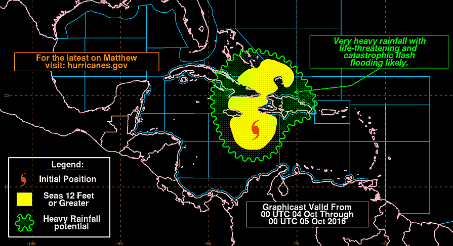
And very wet:
That's given me goose bumps imagining how you feel right now waiting. I was living in Boca in 1985 when a big one struck. Fingers crossed for you.
The more I explore the www.nhc.gov site, the more I find. For info on the progress of MATTHEW, see their Graphics Archive.
Two of these graphics loops are:
Reading between the lines, there is no certainty as to where it will go. There are several models that are being compared to produce the forecasts.
Indeed, fingers crossed for all in the area.
Edit: You've made the news on the BBC: Dangerous storm closes in on Haiti.
Edit2: And this evening you've been downgraded from Hurricane to a Tropical Storm warning...and Matthew is still at Cat 4 (but that is quite bad enough).
Last edited by PickleB; 4th October 2016 at 17:18.
Hey MarkO, how's it going? Haiti is taking a hammering but I guess you've not got a banana leaf roof.....
I'm on Guadaloupe in a couple of weeks, still hurricane season. I'd love to see one (from a position of safety of course!) I've seen a tornado in the USA, but a hurricane is a different order of magnitude.
At the moment we are still waiting- bit cloudy and a little breeze but no rain yet.
Storm moving very slowly so may be 12-24 hrs before we see how bad it will hit us . Outside right now ....

Looking at Storm Tracker it's speeding up but not increasing in intensity. Indeed they've forecast a slight weakening. It seems you'll know all about it around 12h00 UTC (08h00 local) tomorrow.
Hope that you've prepared and nothing untoward happens.
All the best, Bob
Edit: Good morning. Matthew seems to be progressing much as was forecast, but it seems that Nicole is coming to the party. Fortunately, she's well away from the Caribbean: link.
Last edited by PickleB; 5th October 2016 at 08:45.
Providenciales Airport gave up reporting weather observations yesterday...presumably it's closed...so I can't find much real data to see how you're getting on.
However, the satellite image does seem to indicate that you might get away with it being wet and very windy as Matthew seems to have taken a liking to the north coast of Cuba: link.
See also: ...HURRICANE HUNTER AIRCRAFT FINDS CENTER OF MATTHEW NORTH OF EASTERN CUBA...
As of 09h00 UTC (link):
Matthew is moving toward the north near 10 mph (17 km/h). A turn toward the north-northwest is expected today, followed by a northwest turn tonight. Matthew will be moving across the Bahamas through Thursday, and is expected to be very near the east coast of Florida by Thursday evening.
Matthew is expected to produce total rainfall…Turks and Caicos Islands...2 to 5 inches, isolated 8 inches.
Last edited by PickleB; 5th October 2016 at 11:09.
It is just a bit breezy at the moment - no rain yet.
Looks like Matthew spent longer than expected in Cuba and weakened. Now going to strengthen again and go straight up the Bahamas to the Florida coast.
The heavy rain that was to the east of the main storm looks significantly less having flooded Haiti.
I doubt businesses will bother opening today ( just lazy ) but back to normal Thursday
How was it? It seems that Matthew has declined (for the moment) and is off to the Bahamas and Florida.
Almost no effect here - it was overcast with drizzle and a just a stiff breeze so like a British summers day.
Good news...!
Result for you, nice one.
Bah, I wanted to hear tales of hanging onto a coconut tree by your teeth and cows flying past at head height.
Still, very glad you've got off lightly. Have a good'un.
Pity you didn't get your cistern filled though 😶
Maybe in Florida:
Matthew has been moving rather quickly and has eased off a little. It's interesting to see that the Met Office and the NOAA models now disagree as to where the remnants will end up. One predicts Canada and the other has it back in the Caribbean.
Looks like Matthew had a significant impact further up the coast.
Heard from 2 sets of friends in Miami area who are fine with little real problem from the storm.
There is a big Haitian population here and news of 900 known deaths so far is bad - that number is very likely to go up looking at the areas affected.
And then it was gone: Earth Wind Map.
Use:
- 'shift j' & 'shift k' to move back and forward in 1 day intervals
- 'j' & 'k' to move back and forward in 3 hour intervals
- 'n' to return to the most recent data
- ...there are more keyboard shortcuts at the bottom of their 'about' page
Otherwise, click Earth and use the Control functions.
What I hadn't realised previously is that you can also move forward and see forecast data.
Last edited by PickleB; 10th October 2016 at 16:22.
BBC link: Timeshift - The Highs and Lows of British Weather
A national obsession is explored in this archive-rich look at the evolution of the weather forecast from print via radio to TV and beyond - and at the changing weather itself.
 Posting Permissions


